


Brandon's 2020-2021 WINTER WEATHER OUTLOOK
- Brandon Shipp

- Nov 6, 2020
- 5 min read
Updated: Nov 21, 2020

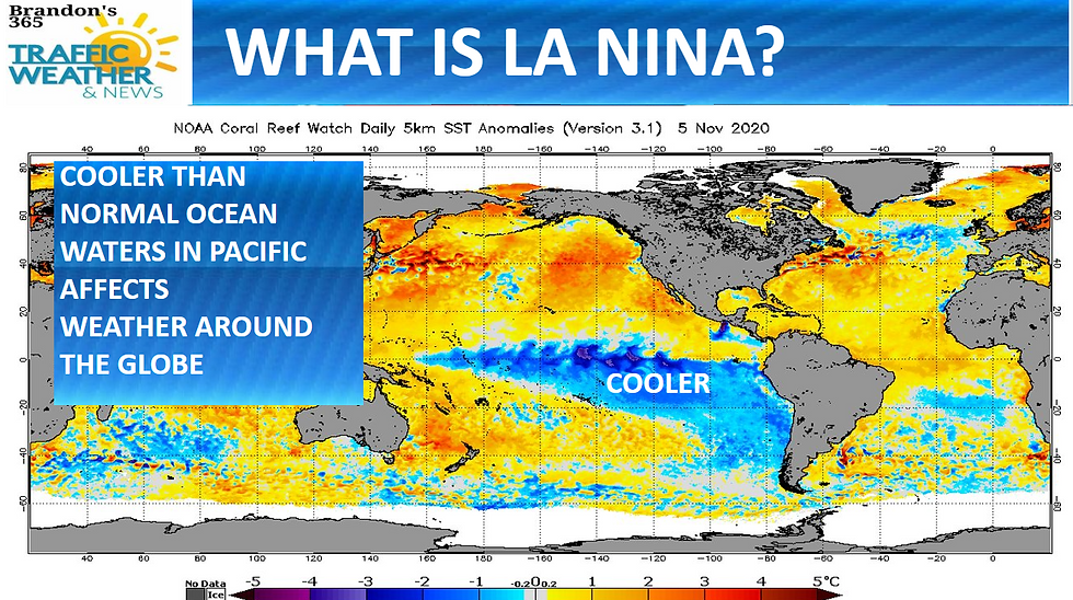


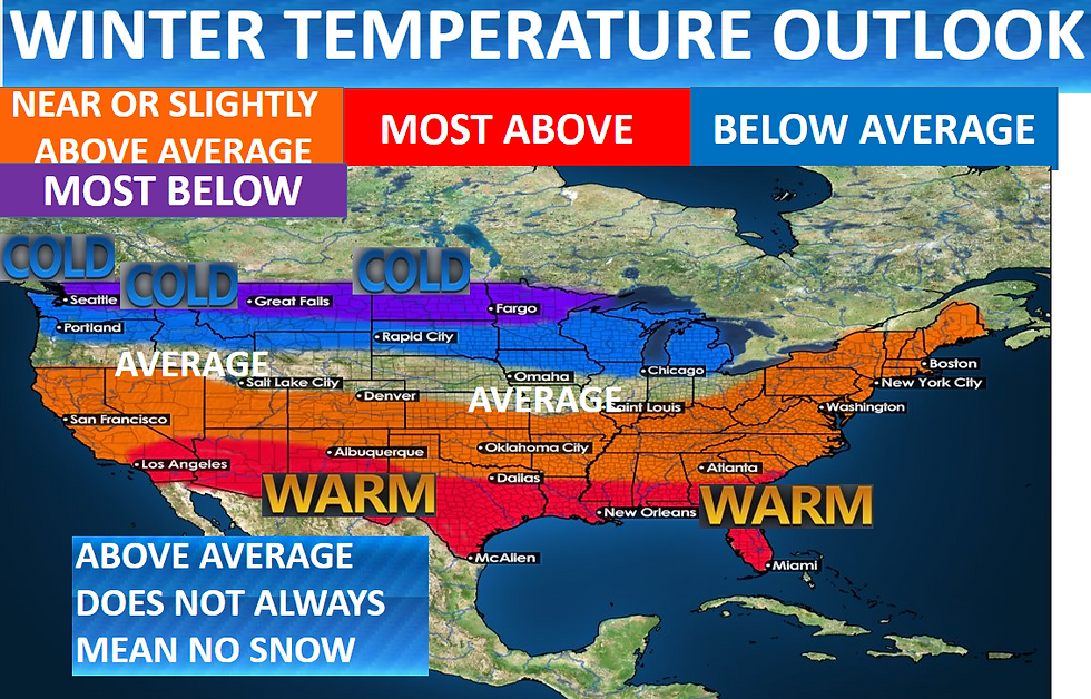

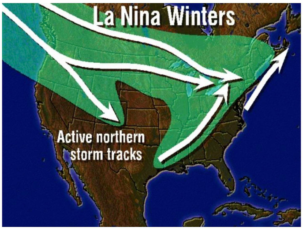
It is that time of year time to look ahead to see what winter might have in store. This is one of my favorite outlooks of the year I learn a lot from the research and I hope you will too. Before going in-depth please keep in mind that meteorology is NOT an exact science, and climate-based meteorological outlooks are more complex than regular 5 and 7 day forecasts. I have been researching various factors that impact Winter Weather Across the South and really for the entire United States from previous Winters (analogs) to sea surface temperatures, Jet stream Patterns, Snow cover over Canada and Siberia. This year we have La Niña. El Niño and La Niña are opposite phases of what is known as the El Niño-Southern Oscillation (ENSO) cycle. The ENSO cycle is a scientific term that describes the fluctuations in temperature between the ocean and atmosphere in the east-central Equatorial Pacific (approximately between the International Date Line and 120 degrees West). La Niña episodes typically last nine to 12 months, but some prolonged events may last for years. While their frequency can be quite irregular, El Niño and La Niña events occur on average every two to seven years. Typically, El Niño occurs more frequently than La Niña. La Niña events represent periods of below-average sea surface temperatures across the east-central Equatorial Pacific. Global climate La Niña impacts tend to be opposite those of El Niño impacts. In the tropics, ocean temperature variations in La Niña also tend to be opposite those of El Niño. Keep in mind just because one area is showing above average temperatures or below average temperatures does NOT mean that it will be really cold or really warm the entire winter. In the South and Southeast including Georgia and Alabama I am forecasting above average temperatures in most areas that is for the winter as a whole compared to average. MOST of our winters are WARMER than average/above average so that is nothing new. There will be SEVERAL Cold Snaps and Warm Spells in the South. ALSO, it is very important to note that a region can have ABOVE Average temperatures and still have near Average snowfall or above average snowfall. I expect much of the northwestern US to have ABOVE AVERAGE precipitation very wet conditions and at times winter weather conditions meaning quite a bit of snow is possible especially in the Cascade mountains. I expect Texas and the southern plains to be mostly dry this does not mean it will not rain at all but precipitation is expected to be below average. Like I mentioned above average temperatures does not mean the entire winter December-February will be extremely warm. In fact looking back over the decades a lot of our really good snows in Georgia and the southeast happened during relatively warm spells as a whole examples include January 9th 2011 the day before the snow it was 59 degrees then we had 3.7" of Snow by the next night, 2014 before a major snow/ice storm shut down Atlanta and Birmingham, temperatures were in the low 60's! One last example there are many as you can tell but before the Blizzard of 1993 temperatures was in the 70's just a few days before. I expect near average to slightly below average precipitation for much of North Georgia including Metro Atlanta. Notice on the map above North Georgia is in between the above average precipitation expected over the Ohio Valley and the well below average precipitation to the south. I expect several major snow storms for Montana, Washington state, parts of Oregon, Idaho, Wyoming, North Dakota, South Dakota, Minnesota and Iowa. The core of the cold air will be along the US/Canadian border especially for parts of Montana, Washington, North Dakota and surrounding states. Right now the Polar Vortex is strong and when it is strong like it is now it does not move as much as it does when it is weak. When the Polar Vortex is weak it can dive south and bring cold air with it. Our last big winter with impacts from the Polar Vortex was winter 2014 particularly January and February 2014 when several snow and ice storms hit and we had significantly cold weather. I found in my research that ice storms are more common during La Niña winters in Georgia 1973, 2000 and 2005 all were La Niña years in Georgia with big ice storms. In 2010 and 2011 also a La Niña event ALL of Atlanta and North Georgia had ABOVE AVERAGE snow and much of the south. La Niña events can bring a variety of weather from big snow and ice storms to severe storms and a lot of dry weather. Back in the winter of 2005 right after our last active hurricane season we only had 0.5" of snow in Atlanta. 2008 was a La Niña event and we had 1.4" of snow in Atlanta. Back in 2000 3" of snow fell in Atlanta. The latest snowfall ever to occur in Atlanta happened back on March 24th 1983 also a La Niña event when over 7" fell in the city of Atlanta with higher amounts west and north of the city. 1983 featured multiple snow storms. Our most recent big snow in Georgia and Alabama was December 2017 when 6 to 12" fell across much of North and West Georgia and eastern Alabama. 2017 was a La Niña event. This winter I think we have a 50% chance 5 in 10 chance of seeing snow at some point in metro Atlanta and North and West Georgia with the higher elevations of the mountains having a 70% chance 7 in 10 chance of seeing snow. Our last white Christmas in Metro Atlanta and North Georgia occurred during a La Niña event (2010). In 1974, 1998, 2005, 2008 and 2011 all La Niña events there was a lot of active severe weather including tornadoes. In March 2008 a tornado hit downtown Atlanta. 1974 and 2011 were both extremely active in terms of severe weather especially in the Spring. I do expect between 2 and 4 severe weather events between now and Summer 2021 for the south. Severe weather occurs most frequently in the spring but can also occur during the winter. We will have to keep an eye on all potential severe weather events but especially any in the late winter and during the Spring of 2021. As you can tell a lot has occurred during La Niña events in the past. Regardless of what this winter brings I'll be here to keep everyone informed every step of the way No Matter The Weather I've Got You Covered!


Below is what is responsible for Most our cold air outbreaks in the US when we have a Negative NAO phase it allows cold arctic air to make it all the way down into the Southern US.


The opposite occurs when there is a Positive NAO phase


Influence of La Niña on the right right on the potential for severe weather the purple areas are more likely to have severe weather at some point during a La Niña event especially during the Spring.


Comments